Jeudi soir:
sommaire (cartes)....
old!!! (voir
+
)
---------- 2006 ----------
92
15/10/2006
- Plateau des 1000 étangs
-
91
12/10/2006
- repas
90
07/09/2006
- vignoble ... Osenbach Bergholtz
v2
-
v3
89
31/08/2006
- cascade et mine
88
24/08/2006
- Col Amic
87
17/08/2006
- Thanner Hubel
86
10/08/2006
- Castella sylva
85
03/08/2006
- Boenlesgrab
-
84
27/07/2006
- orage au Gsang
83
20/07/2006
- lac du Ballon et Haag
3D
82
13/07/2006
- feu d'artifice
-
81
06/07/2006
- abbaye de Murbach
80
01/07/2006
-
info geoportail
79
29/06/2006
- Steinlebach et descente nocturne
78
22/06/2006
- château du Hohlandsbourg
77
18/06/2006
- les balcons d'Orbey
-
76
15/06/2006
- vallée noble
-
75
08/06/2006
- ND de Schauenberg
-
74
01/06/2006
- Hartmannswillerkopf
-
73
25/05/2006
- ...
72
18/05/2006
- ...
71
11/05/2006
- Pastetenplatz
(points)
70
04/05/2006
- Chapelle St Brice
-
69
27/04/2006
- première sortie
-
---------- 2005 ----------
68
06/10/2005
- repas
67
08/09/2005
- cantine Zeller
-
66
01/09/2005
- anniversaire
-
65
25/08/2005
- une ...
64
18/08/2005
- sortie "bricolage"
-
63
11/08/2005
- Strohberg
-
62
04/08/2005
- Hugstein
-
61
28/07/2005
- nobody?
60
21/07/2005
- Dreibannstein
-
59
17/07/2005
- Thur Tour
58
07/07/2005
- pluie
57
30/06/2005
- Michelbach
56
23/06/2005
- Hohlandsbourg
55
16/06/2005
- Schauenberg
-
54
09/06/2005
- Borne jaune
-
53
02/06/2005
- Ebeneck
52
26/05/2005
- Freundstein
51
19/05/2005
- Thanner Hubel
50
12/05/2005
- Baecherkopf-Hisla
-
49
05/05/2005
- cantine Zeller
48
28/04/2005
- Flaxlanden
-
47
21/04/2005
- la première
-
---------- 2004 ----------
46
14/10/2004
- repas
45
09/09/2004
- rocher Ostein
-
44
02/09/2004
- au pied du Vieil Armand
-
43
26/08/2004
- Camp Turenne
-
42
19/08/2004
- ...
41
05/08/2004
- borne jaune
-
40
29/07/2004
- Grand Ballon
-
39
22/07/2004
- Hundsrück
-
38
15/07/2004
- Thanner Hubel
-
37
08/07/2004
- ferme Ostein
-
36
01/07/2004
- ferme du Strohberg
-
35
24/06/2004
- Steinlebach
-
34
17/06/2004
- Gueberschwihr
-
33
10/06/2004
- vallée Noble
-
32
03/06/2004
- pluie
31
27/05/2004
- vignoble
-
30
20/05/2004
- Hartmanswiller
-
29
13/05/2004
- Waldkapelle
-
28
06/05/2004
- ...
27
29/04/2004
- Thanner Hubel
-
26
22/04/2004
- Hirnelestein
-
---------- 2003 ----------
25
02/10/2003
- repas
24
11/09/2003
- rocher d'Ostein
-
23
04/09/2003
- Hirnelestein
-
22
28/08/2003
- carrière de Buhl
-
21
21/08/2003
- Hartmanswiller
-
20
12/08/2003
- camp Turenne
-
19
07/08/2003
- Belaker - Gsang
-
18
31/07/2003
- Freundstein
-
17
24/07/2003
- défilé de Rammersmatt
16
17/07/2003
- Hundsrucken
15
10/07/2003
- Hirnelestein
-
14
03/07/2003
- Boenlesgrab
-
13
26/06/2003
- ...
12
19/06/2003
- vallée Noble
-
11
12/06/2003
- abbaye de Murbach
+ déniv. + 3D
10
05/06/2003
- Thanner Hubel
-
---------- 2002 ----------
09b
26/09/2002
- repas
09
12/09/2002
- Hilsen
-
08
05/09/2002
- pluie
07
29/08/2002
- vallée de Murbach
-
06
11/07/2002
- Boenlesgrab
05
04/07/2002
- Borne Jaune
-
04
27/06/2002
- Lauchenkopf
03
20/06/2002
- Steinlebach - Col Amic
02
13/06/2002
- Judenhut
01
25/04/2002
- ...
be4.free.fr/jeudi/sommaire.htm
- 11/2006 - kch


 (points)
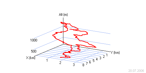
 be4.free.fr/jeudi/sommaire.htm
- 11/2006 - kch
be4.free.fr/jeudi/sommaire.htm
- 11/2006 - kch
be4.free.fr/jeudi/sommaire.htm
- 11/2006 - kch
be4.free.fr/jeudi/sommaire.htm
- 11/2006 - kch